
Walk an Ankeny Street Record
A useful street search separates ownership from occupancy. Polk County tax records identify the taxpayer attached to a parcel, not every person at that address. A recorded deed proves a transfer or other property interest. It does not prove that the grantee moved in. Directory and voter evidence can support a residence link, but each has its own date and access limits.
- Enter the full address in the Polk County Assessor Property Search. Save the parcel number, situs address, legal plat and owner or taxpayer fields.
- Open the parcel in the Polk County GIS viewer. Check its boundary, nearby parcels, subdivision and corporate-limit context.
- Use the legal description and owner name in the Polk County Recorder search. Follow each seller backward through recorded deeds.
- Use the state voter tool only for a known name and ZIP. It has no public street-search field and is not a block roster.
- For older occupants, ask a library about street-order or criss-cross volumes, then confirm the entry against a census, deed or newspaper.
This chain turns one Ankeny address into several dated facts. Keep those dates beside every name. A sale, tax roll, voter confirmation and directory entry may describe different points in time.
Search Ankeny Streets by Address
The assessor form is the strongest first stop for a whole block. It accepts one address, a partial street, a house number, or a number range. City, state and ZIP do not belong in its street-address field. The legacy portal also accepts unit words and wildcard symbols, which helps when an address has changed format.
| Polk field | Input | Street-directory use |
|---|---|---|
| Street Address | Full or partial text | Find one site or a named street |
| Address range | Two numbers joined by : or .. | Review a run of house numbers |
| Last Name / First Name | Owner text | Test a known taxpayer name |
| Plat | Subdivision text | Group parcels by legal plat |
| Parcel | District or geoparcel | Return to an exact tax parcel |
| Value condition | Operator and value | Compare displayed assessment fields |
Run the exact form first. If it fails, check NE, NW, SE or SW and the official street suffix. Preserve apartment or suite text. A range result may omit units, so inspect each parcel rather than assuming every household appeared.
Note: Polk County announced a 2026 assessor-site transition, so verify the live search address and field labels before relying on saved instructions.
Ankeny Street Records Compared
No Ankeny street directory is a complete household list. These official and archival sources overlap, and their limits are part of the answer.
| Address record | Custodian | What it establishes | Access route |
|---|---|---|---|
| Property roll | Polk Assessor | Taxpayer, parcel, situs and legal plat | Free owner/address search |
| Parcel map | Polk GIS | Parcel shape, roads, limits and layers | Public viewer and Atlas |
| Recorded instruments | Polk Recorder | Grantor, grantee, date, kind and legal description | Index from 1992; older imaging or microfilm |
| Permit file | Ankeny Development Services | Address-specific application and project records | One Stop or focused records request |
| Historical directory | DMPL and archival holders | Dated name and address evidence | Digital, print, microfilm or staff help |
| Voter record | Iowa SOS / Polk Elections | Known name and ZIP registration check | Narrow public lookup; restricted list request |
The parcel number connects the assessor to GIS. The legal description connects that parcel to deeds and plats. A street name connects only after directionals, units, city limits and the date have been checked.
Map an Ankeny Street Segment
Polk GIS describes address, parcel-point and subdivision searching. Its published layers include tax parcels, parcel labels, roads, corporate limits, political boundaries, aerial images and selected land, flood and utility context. Search one known parcel, turn on parcel labels and roads, then click adjacent polygons. Record each parcel ID and legal subdivision before leaving the map.
Historical aerials can help date physical change, but they cannot identify an occupant. Corporate limits matter more than the mailing city. An Ankeny postal address may fall beyond Ankeny city limits, changing the office that holds permits or service records. The county warns that map data can change and may be unavailable during maintenance.
- Parcel
- A mapped unit of land with its own county identifier.
- Situs address
- The physical location of the parcel, distinct from the tax-mail address.
- Plat
- A recorded plan that divides land into lots, blocks or streets.
- Criss-cross directory
- A directory arranged by street and house number rather than surname.
Follow Ankeny Deeds by Street
The Polk Recorder index turns a current owner into a chain of recorded events. Search the owner as grantee, open the latest deed, and copy the instrument date, recorded date, kind, file number, book and page, and legal description. Then search the seller as a grantee in an earlier range. Repeat until the web index reaches its 1992 boundary.
Earlier work moves to Recorder imaging or microfilm, Iowa Land Records, and the State Historical Society of Iowa. Polk plat coverage is listed from 1846, and archival deed and town-lot series reach the nineteenth century. Those older books are crucial when a street was extended, a lot was replatted or the modern house number did not yet exist.
A grantor transfers an interest; a grantee receives it. Neither label alone proves residence. Match the legal description, dates and related parties, especially when the same name appears more than once.
Ankeny Permits Need Two Routes
Ankeny One Stop displays permit categories and supports applications, tracking and payment. The inspected page includes building additions, demolition, decks, garages, signs, solar work, sidewalks, right-of-way excavation and other project classes. It is a workflow portal, not a verified all-years public index of people and addresses.
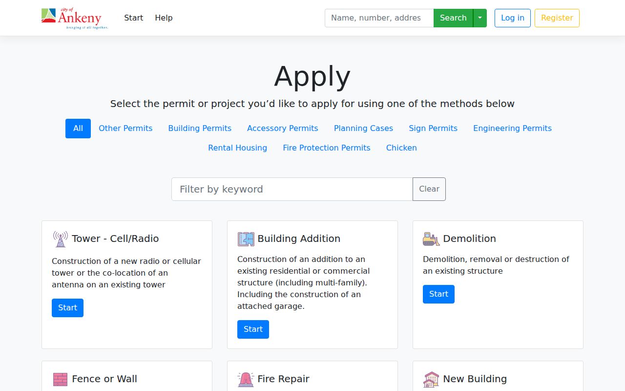
The captured interface shows why a permit number or category helps. For a full address history, request the address, permit class and date range from Development Services or the City Clerk. The city accepts chapter 22 requests by mail, email, fax or in person and may estimate actual costs or ask for clarification.
Development Services is at 1210 NW Prairie Ridge Drive and can be reached at 515-963-3550. A narrow request is more useful than asking for every record tied to a broad street name.
Older Ankeny Streets Need Context
Reverse directories can supply the historical address-to-occupant bridge. The Library of Congress explains that these volumes are usually arranged by street and house number. Exact Ankeny and Des Moines criss-cross years were not verified in the local catalogs, so contact Des Moines Public Library staff instead of assuming an annual run.
There is also a sharp local false positive. A 1920 Polk County directory search for “Ankeny” can return Ankeny Avenue in Des Moines. Check the street guide, city heading and cross streets before treating that hit as a City of Ankeny household. Full coverage of the volumes belongs on the Ankeny city directory page.
Note: OCR may misread initials and house numbers, so the scanned page should control when its text differs from an automated result.
Ankeny Directionals Change Results
NW, NE, SW and SE are meaningful parts of modern Ankeny addresses. Dropping one can point to the wrong road or parcel. A ZIP of 50021 or 50023 helps with mail, but it does not settle city jurisdiction. Compare the assessor situs field, GIS corporate-limit layer and Ankeny city maps.
Annexation can change the city street grid used for emergency response, the permit office, city services and voting. School boundaries remain independent. For an older address, record the date and use plats or annexation documents to translate the location into its present form.
Ankeny Voter Search Is Narrow
The Iowa voter lookup asks for first name, last name and ZIP. It can confirm registration and polling-place information for a known person. It cannot accept a street and should not be described as a public block directory.
A fuller voter-file request has statutory purpose limits, fees and certifications. Iowa law also protects certain data, and Safe at Home may substitute an eligible participant's address. For a legitimate historical street question, ask Polk Elections or the archives about a dated precinct map, poll book or existing register.
Limits of Ankeny Street Directories
An owner name is not the same as a resident name. Trusts, estates, companies and people living elsewhere may own an Ankeny parcel. Tax mail can go to another address. Renters, relatives and other household members may never appear in the property roll. A missing voter result can reflect changed registration details, a protected address or a simple mismatch.
Use the street directory for family history, property research, civic questions and other lawful personal purposes. Verify each conclusion with the office that holds the underlying record. Do not publish private details or turn a dated clue into a claim about a current household.
Lawful use. Ankeny address records must never be used to stalk, harass, threaten or harm a person.